Underground Water Detection Instrument Terrameter for Geophysical Survey Resistivity Imaging System
Basic Info
| Model NO. | WDJD-4 |
| After-sales Service | Yes |
| Warranty | 1 Year |
| Prouct Name | Resistivity Meter for Groundwater |
| Antoher Name | Vertical Electrical Sounding for Groundwater Inves |
| Survey Depth | 300m |
| Software | 1d/2D/3D |
| Transport Package | Wooden Box |
| Specification | CE/ISO/FCC |
| Trademark | GOLD |
| Origin | China |
| HS Code | 9002209000 |
| Production Capacity | 1000 |
Product Description
Underground Water Detection Instrument Terrameter for Geophysical Survey Resistivity Imaging System
What's mainly application about geophysical Resistivity Imaging System?
Resistivity imaging systems provide a non-invasive and cost-effective method for mapping subsurface structures and features, making them valuable tools for a wide range of applications in environmental studies, mineral exploration, geotechnical investigations, archaeology, civil engineering, and the oil and gas industry.
1.Metal and nonmetal mineral resources detection
How to work about geophysical Resistivity Imaging System?
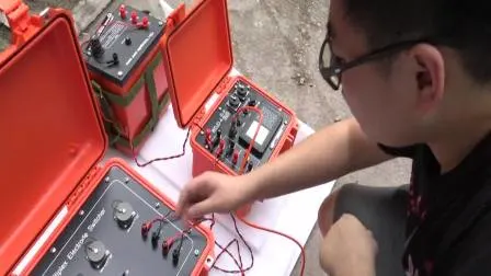
The system involves injecting an electrical current into the ground through two electrodes, which are typically positioned on the surface of the ground.
The electrical current flows through the subsurface materials, encountering different levels of resistivity as it passes through different types of geologic materials.
The resistivity of the materials affects the distribution of the electrical current, causing it to flow more easily through conductive materials (such as water or mineral deposits) and less easily through resistive materials (such as rocks or soils).
The electrical potential difference between two additional electrodes is then measured, which allows the system to calculate the resistivity of the subsurface materials along a series of lines or grids.
The resistivity values are then processed and displayed as 2D or 3D images, which can be used to map the subsurface geologic features and identify potential targets for further investigation.
How to choose suitable geophysical resistivity meter?